![]()
![]()
![]()
Allows to set up a connection with a Web Map Service through a dialog box.
Before adding map data to a drawing, the GEOGRAPHICLOCATION command must be executed to define and store the appropriate geographic location data in the drawing.
Accessing the Command
command bar: mapconnect
: mapconnect
Displays a dialog box:
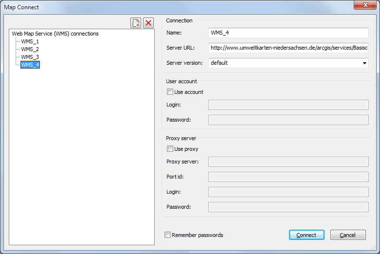
Command Options
|
Option |
Description |
|
Name |
(option) Type a name to replace the default WMS<x> name. The 10 most recently used connections are saved. |
|
Server URL |
Specify the URL of a Web Map Service. |
|
Server version |
Specify a server version or select one in the drop-down list. |
|
User Account |
|
|
Use Account |
Check the option if the Web Map Service uses a login and password. |
|
Login |
Type the login. |
|
Password |
Type the password |
|
Proxy Server |
|
|
Use Proxy |
Check the option if you want to use a proxy server to connect to the Web Map Server. |
|
Proxy server |
Type the URL of the proxy server. |
|
Port Id |
Specify the port to use for the connection. |
|
Login |
Type the login. |
|
Password |
Type the password. |
|
|
|
|
Remember passwords |
Check the option if you want passwords to be remembered for future use. |
Do one of the following:
Select a previously used Web Map Service in the list.
Fill in the necessary fields and click the Connect button.
A dialog box displays:
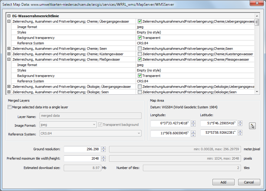
Do the following:
Select one or more data layers
Specify the desired ground resolution and the preferred maximum dimensions of a tile.
An estimate of the download size displays in the Estimated download size field.
Press the Add button.
Downloaded map tiles are stored as regular image files in the folder where the drawing is saved.
The definition of the supported Coordinate Reference Systems (CRS) is stored in the new geodatabase.xml file which is located in the folder pointed to by the ROAMABLEROOTPREFIX variable, e.g. C:\Users\John\AppData\Roaming\Bricsys\BricsCAD\V15x64\en_US\Support
Also contained in geodatabase.xml is a list of cities and their WGS84 geo coordinates which is used by the "Choose Location..." functionality of the Geographic Location dialog.
Related Commands
Geographiclocation - sets the geographic location of the drawing.
Image - inserts images in drawings through the Drawing Explorer.
| © Menhirs NV. All rights reserved. |