![]() Pro, Platinum
Pro, Platinum![]() Pro, Platinum
Pro, Platinum![]() Pro, Platinum
Pro, Platinum
Sets the geographic location of the drawing.
Accessing the Command
command bar: geographiclocation
alias: geo
toolbar: Render | ![]()
: geographiclocation
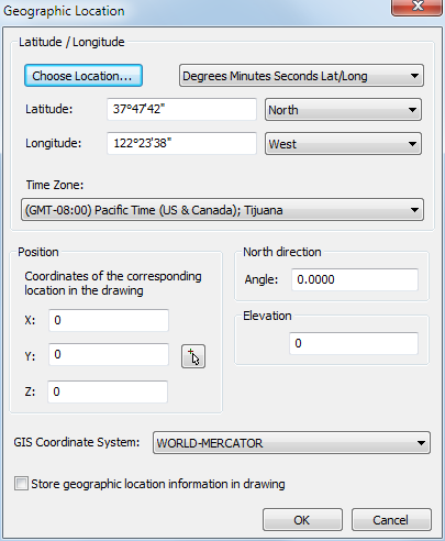
Displays a dialog box:
Settings
|
Setting |
Description |
|
Choose Location |
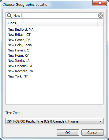
Displays the Choose Geographic Location dialog box.
|
|
|
|
|
Latitude |
Sets the latitude of the drawing in either Degrees/Min./Sec. or decimal format. The valid range is 0 to 90. Choose North or South from the latitude option button. The value is saved to the LATITUDE system variable. |
|
Longitude |
Sets the longitude of the drawingin either Degrees/Min./Sec. or decimal format. The valid range is 0 to 90. Choose East or West from the longitude option button. The value is saved to the LONGITUDE system variable. |
|
|
|
|
Timezone |
Choose a time zone from the Time Zone drop down list. The setting is saved to the TIMEZONE system variable. |
|
Position |
Defines the position of the selected location in the drawing. Either type the coordinates in the X-, Y- and
Z-fields or click the Pick Point
button ( Optionally, type a value in the Elevation field. |
|
North Direction Angle |
Specifies the angle of the sun from north, in the context of the world coordinate system. The setting is saved to the NORTHDIRECTION system variable. |
|
|
|
|
GIS Coordinate System |
Choose a coordinate system from the list. |
|
|
|
|
Store geographic location information in the drawing |
If checked, a red dot indicates the position of the selected location in the drawing. |
Related Commands
Render - calculates a photorealistic image of the 3D model.
Sunproperties - displays the Sun Properties of the Active Viewport editor in the Drawing Explorer - Lights dialog.
MapConnect - allows to set up a connection with a Web Map Service through a dialog box.
| © Menhirs NV. All rights reserved. |