Works with Bricscad (Windows) Classic and Pro, Bricscad (Linux) Classic
Attaches raster images to the drawing.
Accessing the Command
command bar: imageattach
transparent: 'imageattach
alias: iat
menu bar: Insert | Image Attach
toolbar: Images | ![]()
: imageattach
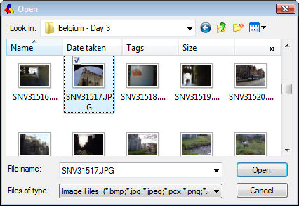
Displays a dialog box:
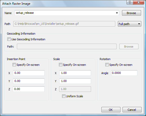
Specify options, and then click OK.
This command inserts the following file formats into drawings:
BMP - Windows bitmap.
JPG, JPEG and JPEG2000 (JP2, j2k) - Joint Photographic Experts Group (common among digital cameras).
PCX - PC Paintbrush.
PNG - Portable network graphics.
GIF - CompuServe graphic image format.
TGA - Targa.
TIF - Tagged image format (commonly used by desktop publishing).
ECW - Enhanced Compressed Wavelet format.
SID - MrSID is an acronym for Multi-resolution Seamless Image Database.
Command Options
|
Options |
Description |
|
Specifies the file name of the image. |
|
|
Displays the Open dialog box; click this button to choose a different raster file.
Choose a raster file, and then click Open. |
|
|
Path |
Reports the path to the image file; cannot be edited by the user. |
|
Determines how much of the path is stored:
c:\foldername\imagename.ext
..\foldername\imagename.ext where .. refers to the folder above the current one.
|
|
|
|
|
|
Geocoding Information |
Position files or world files have an extension that depends on what kind of image file they are associated with. See explanatory notes below: "About Geocoding Information". |
|
Toggles use of a position file, which specifies the size, location, and rotation of the image file:
|
|
|
Reports the path to the position file. |
|
|
Displays the Select Image Position File dialog box; choose a TWF file, and then click Open. |
|
|
|
|
|
Positions the lower left corner of the image in the drawing. This option is unavailable when a position file is used. |
|
|
Toggles where you specify the insertion coordinates:
Insertion point - specify the x,y or x,y,z coordinates of the image's lower left corner. |
|
|
Specifies the x coordinate of the image's lower left corner. |
|
|
Specifies the y coordinate of the image's lower left corner. |
|
|
Specifies the z coordinate of the image's lower left corner. |
|
|
|
|
|
Sizes the image. This option is unavailable when a position file is used. |
|
|
Toggles where you specify the scale factors:
Scale factor - specify the scale factor. |
|
|
Specifies the scale factor in the x direction:
|
|
|
Specifies the scale factor in the y direction |
|
|
Specifies the scale factor in the z direction. |
|
|
Makes the Y and Z scale factors equal to X. |
|
|
|
|
|
Rotates the image about the insertion point. |
|
|
Toggles where you specify the rotation angle:
Rotation angle - specify the angle. |
|
|
Specifies the rotation angle about the insertion point.
|
|
Position files (or world files) are plain ASCII text files that position raster files in the drawing. They are useful for positioning images according to geographic coordinates, such as latitude and longitude. They can be created using text editors such as Notepad.
The format is:
Pixel x-size (width of image).
Rotation about the y axis (0 if no rotation).
Rotation about the x axis (0 if no rotation).
Negative pixel y size (height).
x coordinate of the upper left pixel center (starting location).
y coordinate of upper left pixel center (starting location).
Numbers can be accurate to 0.0000000000 decimal places.
Typically, the first and last letters of the image extension are used with a ”w” added at the end. Sometimes the full image extension with a ”w” at the end is used also.
The following position file formats are supported:
*.bpw (for BMP images)
*.jgw (for JPG images)
*.gfw (for GIF images)
*.tfw (for TIFF images)
*.j2w (for JPEG2000 images)
*.sdw (for SID images)
Related Commands
Image - controls the parameters of the image file.
ImageAdjust - changes the properties of images through the Properties palette.
ImageClip - clips images.
ImageFrame - toggles the display of the frame around images.
ImageQuality - toggles the quality of the image.
Transparency - toggles the transparency of monotone images.
| Bricscad™ is commercialized by Bricsys NV. Bricsys NV and Vondle NV are fully owned subsidiaries of Menhirs NV. Copyright © 2001- Menhirs NV - All rights reserved. |