When you create entities in a drawing, they are located in relation to the drawing's underlying Cartesian coordinate system. Every drawing has a fixed coordinate system called the World Coordinate System (WCS).
You can also define arbitrary coordinate systems located anywhere in three-dimensional space. These are called user coordinate systems (UCS) and can be located anywhere in the WCS and oriented in any direction.
To specify points and distances using the keyboard you can use the following formats:
Cartesian coordinates: x,y,z
Cylindrical coordinates: R<alpha,z
Spherical coordinates: R<alpha<beta
If you place the @-character in front of the entry, the coordinates are calculated with respect to the previous point. This technique is called: Relative Coordinates.
When Dynamic Dimensions are active and you type a value in the Length field and add a comma (,) the content of the Length field is copied to the command line and the @-character is placed in front automatically, which allows you to specify the next point using relative coordinates with respect to the previous point.
When a user defined coordinate system is active you can enter absolute coordinates (World coordinates) if you place an asterisk (*) in front. E.g. *0,0 refers to the origin of the WCS (World Coordinate System).
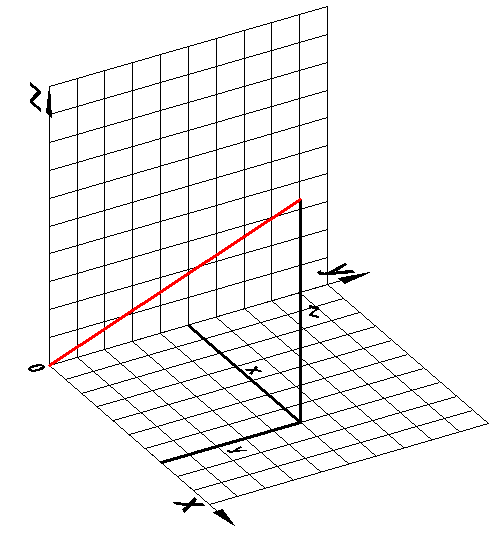
In the Cartesian coordinate system we use three perpendicular axes: the x-axis, the y-axis and the z-axis. All axes originate in the origin point of the coordinate system. The x-axis and the y-axis define a horizontal plane, while the x-axis and the z-axis and the y-axis and the z-axis define vertical planes. A point is defined by its distances to the yz-, xz- and xy- planes. These distances are called the xyz-coordinates of a point.
If you want to enter the absolute Cartesian coordinates of a point, type the x-, y- and z- coordinates separated by commas: 45.5,57.3,60
If you omit the z-coordinate, the point is placed in the xy-plane (Z = 0).
If you place the @-character in front of the entry (@x,y), the coordinates are calculated with respect to the previous point. This technique is called Relative Cartesian coordinates.
Using relative Cartesian coordinates to draw a rectangle
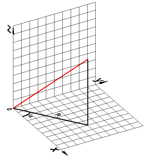
In a cylindrical coordinate system we use three perpendicular axes: the x-axis, the y-axis and the z-axis. All axes originate in the origin point of the coordinate system. The x-axis and the y-axis define a horizontal plane, while the x-axis and the z-axis and the y-axis and the z-axis define vertical planes.
A point is defined using the following format: R<alpha, z.
R = distance to the origin in the xy-plane
<alpha = the angle between R and the x-axis (positive angles are measured counter clockwise)
z = the height above the xy-plane.
If the z-coordinate is omitted, cylindrical coordinates are referred to as polar coordinates.
If you place the @-character in front of the entry, the coordinates are calculated with respect to the previous point. This technique is called Relative Cylindrical coordinates.
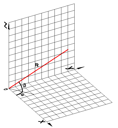
In a cylindrical coordinate system we use three perpendicular axes: the x-axis, the y-axis and the z-axis. All axes originate in the origin point of the coordinate system. The x-axis and the y-axis define a horizontal plane, while the x-axis and the z-axis and the y-axis and the z-axis define vertical planes.
A point is defined using the following format: R<alpha<beta
R = distance from the origin
<alpha = angle in the xy-plane (positive angles are measured counter clockwise)
<beta = angle measured from the xy-plane (positive angles are measured counter clockwise, above the xy-plane)
| © Menhirs NV. All rights reserved. |